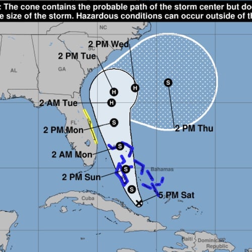
A weather system in the Atlantic Ocean has officially become a tropical storm Sunday as it gathered steam while nearing the southeast U.S. coast and is expected to become a hurricane in the next few days.
The system, which became a tropical depression Saturday morning, will have minimal impacts on Georgia as forecasters believe it will turn east off the Florida coast and won’t hit the U.S. directly.
As of 2 p.m. Sunday, Tropical Storm Imelda was located about 370 miles southeast of Cape Canaveral, Florida, with maximum sustained winds of 40 mph — up from 35 mph that morning, according to the National Hurricane Center.
The system was moving north at about 7 mph. It was expected to strengthen and become a hurricane by late Monday or Tuesday, the NHC said. A tropical depression is a low-pressure area with winds up to 39 mph while tropical storm wind gusts can reach up to 73 mph.
The center of the storm is expected to remain offshore, but there is still a risk of heavy rainfall and winds for the southeast coast, officials said. It will travel across the Bahamas by Sunday night before turning east-northeast as it moves away from the southeastern U.S. in the coming days, the NHC said.
Florida’s east coast was under a tropical storm watch Sunday as rainfall and strong winds from the system are projected to impact the state and areas southeast of the peninsula over the weekend.
Tropical storm conditions were possible in Florida starting Monday and heavy rainfall could lead to flash flooding through Wednesday in the coastal Carolinas, where between 2-4 inches of rain is expected, the NHC said. Depending on the storm surge, the NHC added that water levels could reach up to 2 feet above ground in some coastal areas from the Volusia/Brevard County line in Florida to the South Santee River in South Carolina.
In recent days, the governors of North and South Carolina each declared a state of emergency in preparation of the storm.
But on Sunday, forecasters said they expressed increased confidence that the storm will make “an eastward turn off the Florida” coast.
“The size of the wind field will likely increase early/mid next week as storm slows down, then moves eastward,” the National Weather Service in South Carolina said.
The Georgia Emergency Management and Homeland Security Agency predicted 2-3 inches of rain in eastern and coastal Georgia counties between Monday and Wednesday. The storm will likely have “minimal impacts on North and Central GA,” as it moves east, according to the NHC.
“Current track would bring some isolated showers to the area Monday & Tuesday, with breezy easterly winds throughout the week,” the NWS in Atlanta said Sunday.
Still, GEMA/HS said it was prepared and would have resources, such as water, tarps, sandbags and ready-to-eat meals, at warehouses across the state for quick deployment. Gov. Brian Kemp told reporters in Savannah on Friday during the Georgia Tourism Conference that authorities were watching the weather.
Both Cuba and the Bahamas, where a tropical storm warning was issued, were warned about possible flash flooding and mudslides as the center moved across Sunday, according to the NHC.
Last September, Hurricane Helene claimed nearly 150 lives after making landfall in Florida as a Category 4 hurricane, according to the National Oceanic and Atmospheric Administration. The historic storm caused $79 billion in damage across the Southeast, with parts of Georgia still facing a long recovery.
About the Author
Keep Reading
The Latest
Featured


